Pre-positioning vital for effective humanitarian relief
Last-mile deliveries don’t only apply to commercial undertakings; they’re equally important when it comes to humanitarian relief, writes GERARD DE VILLIERS.
Commercial supply chains consist of a network of links and nodes between origins and destinations. The nodes include intermodal terminals and freight logistics hubs located in the most cost-effective places to serve the market, while the final link to the destination is called the “last mile”. This is probably the most important link due to it being the most expensive, with relatively small delivery loads in congested destinations where economies of scale are not possible.
This is equally true for pre-positioning relief items at cost-effective locations in humanitarian supply chains. The same principles also apply to ensuring the “last mile” to the operational area is as cost-effective as possible for emergency response. The objective remains to increase the yield of scarce resources being committed to humanitarian relief.
Disaster events
Covid-19, the tragic war in Ukraine, and recent devastating earthquakes in Turkey and Syria are all examples of disasters that highlight the need for pre-positioning at cost-effective locations. The Emergency Events Database of the Centre for Research on Epidemiology of Disasters (CRED) maintains an extensive and detailed international database of disaster events, which is very useful to map and analyse the global occurrence of these events.
The UNHRD Network
The United Nations Humanitarian Response Depot (UNHRD) has developed a network of five strategically located depots* that procure, store, and transport emergency supplies to disaster event locations worldwide, on behalf of the humanitarian community. The depots are located at Brindisi, Italy; Dubai, United Arab Emirates; Accra, Ghana; Panama City, Panama; and Kuala Lumpur, Malaysia.
In addition to the global UNHRD network, there are numerous smaller scale initiatives that coordinate the pre-positioning of relief items. One such example is the Emergency Supply Pre-positioning Strategy (ESUPS), hosted by Welthungerhilfe (WHH) in Germany. WHH is currently working in Nepal, Philippines, Indonesia, Vietnam, Madagascar, Colombia, and Honduras; it has developed a platform called STOCKHOLM (STOCK of Humanitarian Organisations Logistics Mapping).
Centre-of-gravity analysis
The UNHRD depots serve a very useful purpose at a global level, but it might be necessary to consider also providing facilities at a regional level to ensure prompt response. It is well-known that the first 72 hours are crucial for saving lives, hence the pre-positioning of relief items should be as close as possible to disaster locations. Centre-of-gravity analysis is very useful for this purpose and a visual example of its application is provided in Figure 1. This is based on data from the Emergency Events Database mentioned earlier. It includes geophysical, meteorological, hydrological, climatological, biological, and extra-terrestrial events (e.g., asteroid strikes, solar radiation storms, and geomagnetic storms) in Africa between June 2014 to January 2017.
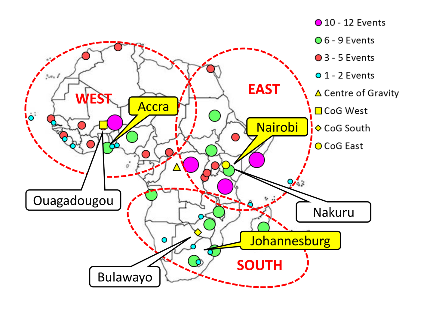
The centre of gravity for West Africa is located at Ouagadougou, the capital of Burkina Faso. The centre of gravity for Southern Africa is at Bulawayo, Zimbabwe, while the centre of gravity for East Africa is located at Nakuru in Kenya. These locations provide an indication of where the most appropriate places to position depots may be; once outliers have been removed and practical realities taken into consideration, specific recommendations can be made. These include that the western cluster be served from Accra, Ghana (where UNHRD currently has a depot), the eastern cluster from Nairobi, Kenya, and the southern cluster from Johannesburg, South Africa.
The most important part of this technique is to get an indication of where the events are likely to happen, or – in the case of commercial supply chains – where the supply and demand is. Once this has been determined, a relatively simple scientific analysis provides guidance for the location of pre-position facilities.
After the locations have been determined at a macro level, more analyses will be required at a micro level to ensure that qualitative factors such as road accessibility, rail accessibility, environmental and geotechnical conditions, land-use, and spatial development guidelines are taken into account.
Conclusion
It is clear that network design, as used for commercial supply chains, can equally provide beneficial guidance for the development of facilities for pre-positioning emergency relief items, to ensure the most cost-effective distribution to the field. This will simultaneously provide an increased yield of scarce resources to the beneficiaries.
* A sixth UNHRD depot at Las Palmas, Spain, appears to have been closed recently.
UNHRD unpacked
The United Nations Humanitarian Response Depot (UNHRD) is an international network of five humanitarian support hubs located strategically around the world to provide supply chain solutions to the international humanitarian community.
It is managed by the World Food Programme (WFP) and currently serves 86 partners, such as UN organisations, government agencies, and NGOs. The UNHRD enables these partners to assist people affected by natural disasters or other complex emergencies, by prepositioning vital relief items and allowing them to be dispatched rapidly to critical areas. In addition, the UNHRD network offers services and knowledge that allow various humanitarian partners to fulfil their missions rapidly and effectively.
The original UNHRD depot was inaugurated in Brindisi, Italy in 2000. In 2006, based on its own requirements and that of its partners, WFP replicated the successful Brindisi model by setting up further emergency humanitarian response depots (HRDs) in strategic locations to create the worldwide network encompassing Europe, Africa, the Middle East, Southeast Asia, and Latin America.
Each of these locations has been selected to provide easy access to an airport, port, and road systems, opening up access to a wide range of transportation methods and allowing for consistently low response times of 24 to 48 hours.
When governments, UN agencies, and NGOs look to respond quickly and efficiently to a disaster, they call on emergency supplies that are immediately available in UNHRD warehouses. By prepositioning relief items, the humanitarian community can support affected people at the onset of an emergency, often saving lives within the first 24 to 48 hours. The UNHRD offers a range of supply chain solutions to relief organisations around the globe, acting as a “one-stop shop” offering storage, procurement, transport, handling, stock borrowing, technical field assistance, and training centre facilities to its partners.
Figure Sources: https://unhrd.org/ and https://wikipedia.org
Published by

focusmagsa


